Introduction
In today’s rapidly developing world, the demand for infrastructure is increasing in unprecedented ways. This has led to the construction of various critical structures such as roads, highways, railways, bridges, and embankments. However, constructing these structures on weak or soft ground presents a unique set of challenges. One of the most significant challenges is to ensure that, for instance, embankment movement and deformation remain within acceptable limits to ensure their stability and serviceability.
To tackle these challenges, it is imperative to conduct proper engineering analysis and evaluation that accounts for the impact of the construction stages, loading sequence, and soil structure interactions. Accurate predictions of movement and settlement are also crucial for ensuring the project’s success.
In this case study, we show how Finite Element Method (FEM) analyses, combined with InSAR remote sensing monitoring, helped to complete an embankment project on soft ground and peat, safely and cost-effectively. The combination of FEM analyses and InSAR remote sensing monitoring provided a comprehensive understanding of the ground behavior and enabled real-time monitoring of the embankment’s movements and deformations.
In the following sections, we will discuss this case study in more detail and delve deeper into the innovative solutions used to overcome the challenges presented by constructing embankments on soft ground.
Case Study
Robroyston, located in Glasgow, Scotland, is currently experiencing a surge in development with the construction of 1,600 new homes. In addition, a new railway station will be conveniently situated by a park and ride service located by the M80. A link road between the existing M80 junction and the new station and car park is necessary to accommodate this growth. This link road involves the construction of an embankment, which is the focus of our case study.
Challenges to the Project
Constructing the embankment is a pivotal aspect of the project, necessitating an in-depth analysis of the surrounding terrain, soil composition, and drainage systems. However, the heterogenous nature of the ground conditions beneath Robroyston’s embankment presented a significant challenge. The site comprised an old ash tip and several pockets of soft peat, making the construction process even more complex. Therefore, ground improvement measures were crucial to prevent potential differential settlement, which could result in a distorted road surface.
Furthermore, the absence of reliable data from previously installed settlement monitoring instruments, particularly Hydrostatic Profile Gauges (HPGs), complicated matters further.
Stratum®
The TensarTech Stratum solution, combined with 3D FEA (PLAXIS 3D) and InSAR monitoring, offers a cost-effective and efficient solution to improve ground conditions. The Stratum is a ground improvement method that consists of geocell mattresses that create a three-dimensional honeycomb structure which distributes the load evenly, minimizing differential settlement, and provide savings in materials, labor, and installation time while ensuring a structurally sound embankment.
The 3D FEA (PLAXIS 3D) provides a detailed assessment of stability and load-bearing capacity, and InSAR monitoring offers insightful detection of ground movement and settlement. Together, these technologies provide a reliable and safe solution for long-lasting embankments.
FEM and InSAR
Following the implementation of the soil improvement measure, it was necessary to establish an appropriate analysis method to ensure the stability and safety of the embankment. Our team conducted an extensive review of the site data and a thorough reconnaissance study to develop a set of geological scenarios and models that account for the variability and uncertainties in the ground conditions.
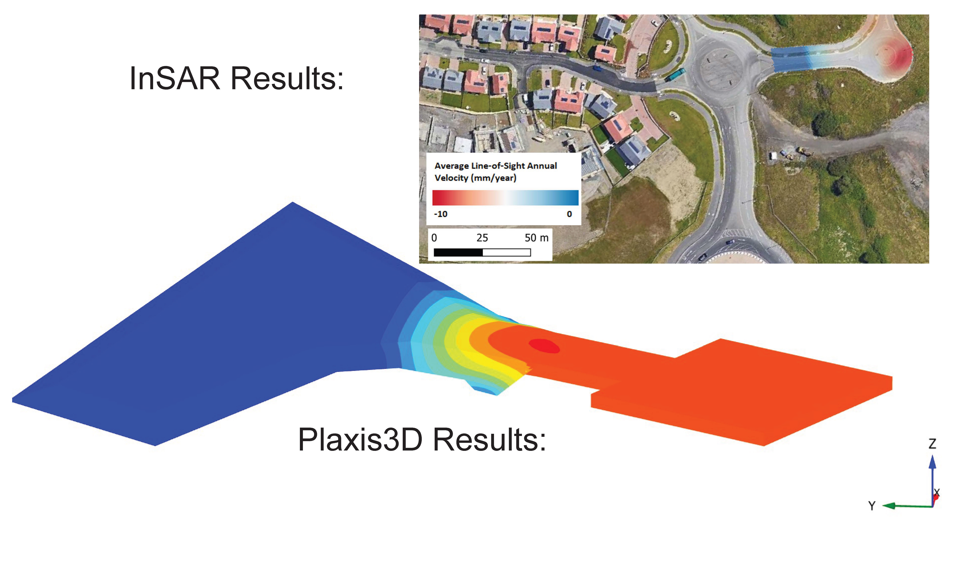
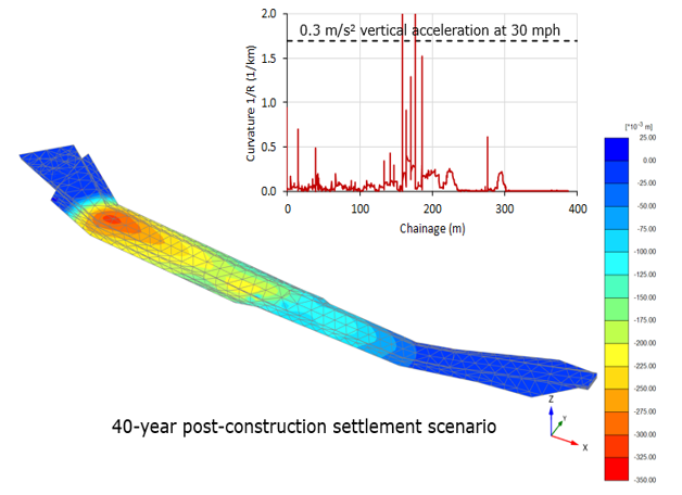
We then utilized 3D Finite Element Method (FEM) analysis using PLAXIS 3D software to perform parametric and sensitivity studies. These analyses incorporated a soft soil creep model to predict the differential movements range in transverse and longitudinal directions, including the time-dependent (creep strains) for the peat materials. This allowed us to predict potential ground movements in several geological scenarios and help ensure the structural integrity of the embankment.
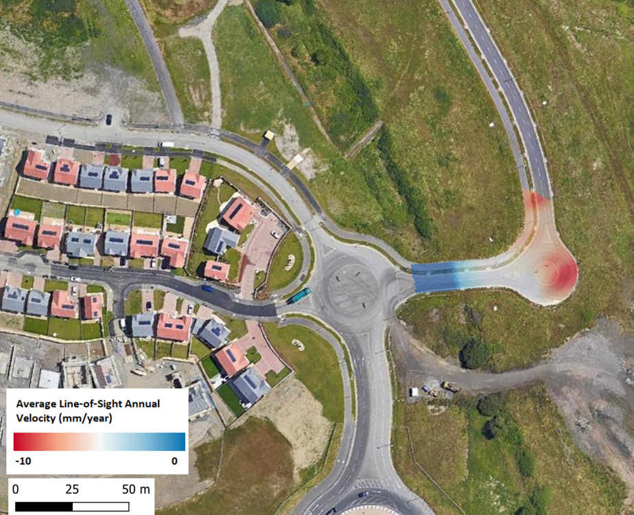
We also utilized remote sensing technology called Interferometric Synthetic Aperture Radar (InSAR) to enhance our monitoring capabilities further. This allowed us to perform real-time, cost-effective monitoring which covered the entire embankment section after construction. The InSAR measurements provided valuable insights into the actual deformations and settlement that occurred and showed that they were within the range predicted by the FEM analyses.
Thanks to these innovative and scientifically sound analysis and monitoring techniques, we could confirm that no further settlement mitigation measures were necessary. Our commitment to utilizing cutting-edge technology and approaches has ensured that the Robroyston embankment is safe, stable, and can withstand the demands of modern transportation.
Benefits
We are pleased to announce that we have successfully verified the effectiveness of the selected ground improvement method, Stratum, through innovative and cost-effective techniques. By coupling our FEM analyses with InSAR monitoring, we could accurately track the embankment’s performance without requiring extensive and costly in-situ surveying.
Our comprehensive analysis and monitoring approach enabled us to demonstrate the reliability of the Stratum method and its ability to deliver results comparable to other ground improvement methods while also providing significant cost savings of up to £500k for the Glasgow City Council. Additionally, our adoption of the Stratum method offers enhanced robustness in construction duration and reduced environmental impact, making it a sustainable and responsible choice. We are proud to have contributed to the sustainable development of the Glasgow area and look forward to continuing to provide innovative and effective solutions for our clients.
Conclusion
In conclusion, we have demonstrated that coupling InSAR monitoring with FEM analysis is a highly effective approach for delivering reliable and cost-effective geotechnical designs. By leveraging cutting-edge technology and innovative solutions, we have provided our clients with a more comprehensive understanding of proposed solutions, ultimately resulting in cost savings and enhanced safety.
Our commitment to providing sustainable and responsible solutions has enabled us to serve society while delivering significant benefits for our clients and engineers. By reducing costs and saving time, we can provide efficient solutions that can be implemented quickly.
Overall, we believe that coupling InSAR monitoring with FEM analysis represents a game-changing approach to geotechnical design that will become increasingly important in the years to come. As we continue to explore modern technologies and approaches, we remain dedicated to providing the best possible outcomes for our clients, engineers, and society.