Increasing the efficiency of a road project that will increase the efficiency of major road network
Value Engineering of Warsaw, Poland specializes in designing road infrastructure at every stage of investment implementation, from study work to detailed projects and supervision of construction work. Within the organization, there are design teams for road, bridge, land improvement, sanitation, electrical, telecommunications, surveying (GIS), geotechnical and traffic safety devices.
Bentley’s civil engineering experts spoke to Value Engineering’s Primary BIM Manager, Michal Lorenz, to learn more about what digital tools they use and how those tools supported their work on the Programmatic Concept Elements for the S7 Road in Warsaw.
Q. Mr. Lorenz can you tell us a bit about this interesting project?
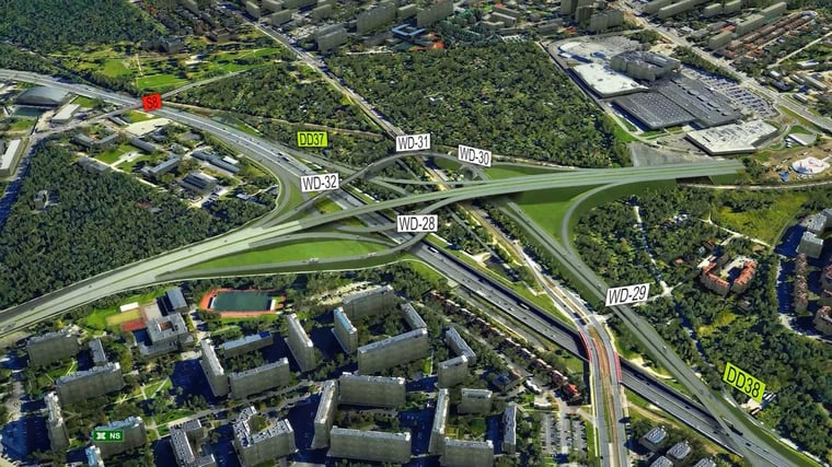
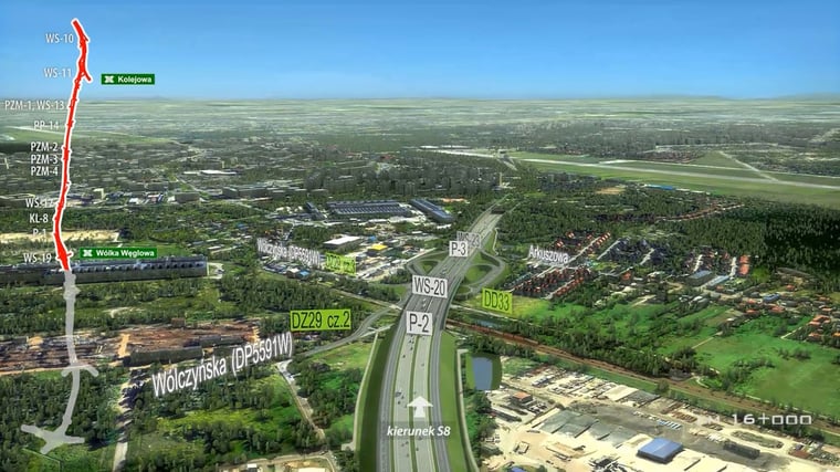
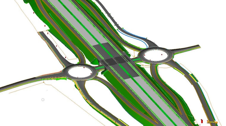
The proposed section of the S7 road is in the Warsaw metropolitan area and is a key element of the planned network of highways and expressways in Poland. Its implementation will increase the efficiency of the road network for transit traffic on the Warsaw-Elblag-Gdansk section, improve the accessibility of Warsaw, and improve the quality of life of residents by reducing transit traffic on the existing national road number 7. The subject section will also provide a connection between existing sections of the S7 road to the north of Warsaw with the existing expressway S8 in the city and the network of high-speed roads in other directions from the capital of Poland. As part of the project, five road interchanges (four of which are located in Warsaw) and two road tunnels in the Bielany and Bemowo districts will be constructed.
Q. What was Value Engineering asked to deliver for your client on this project?
Our team’s scope was deep and broad. Our design work included:
- Programmatic Concept Elements containing detailed technical solutions contained in the Decision on Environmental Conditions for the implementation of the project and previous design studies,
- Traffic forecast,
- Road tunnel concept,
- Geological studies,
- Accompanying studies in the field of Traffic Management System, Rescue Action Plan, etc.
Q. Can you share with our readers what the expected results were or what you and the client hoped to achieve?
During the implementation of the design task, there were no nationwide BIM standards for infrastructure investments yet. The Investor (General Directorate for National Roads and Motorways) was preparing the first tender for design tasks that included BIM elements. Due to the lack of requirements set by the Investor, an internal goal within the organization was set to conduct a pilot project using 3D modeling tools. Undertaking this task aimed to prepare the organization for the challenges associated with the imminent creation and implementation of a national BIM standard for infrastructure projects, as well as to enable participation in such projects in other countries.
As part of the pilot, the possibilities of the software in the field of road, drainage, sanitation and electrical engineering design, coordination between them, and preparation of 2D documentation based on created models were to be tested. In addition, special attention was to be paid to the possibilities of parametric modeling of objects, which were to significantly contribute to the simplification of the process of measurement and cost estimating of construction work. One of the project's basic goals was to test methods for preparing a model of the existing state, particularly underground infrastructure. Specific goals were also defined in terms of creating and verifying our own naming standard for both files and Workspace elements as well as LOD level for the programmatic concept stage. An additional goal related to contractual requirements was to reduce the work related to preparing visualizations of design solutions. Proper preparation and accuracy of the 3D model allowed to eliminate a significant range of unnecessary editing work when creating a film with a visualization of the investment.
Q. Were there challenges you encountered in this project that led to the decision to invest in solutions and applications from Bentley?
Yes, there were. I’d classify the challenges into 4 key groups:
- Inter-disciplinary coordination resulting from the level of complexity of the proposed buildings, the level of urbanization of the existing area (Warsaw and Łomianki), and terrain constraints resulting from the scope of the Environmental Conditioning Decision obtained,
- Analysis of multiple solution variants resulting from the design phase (concept),
- Detailed cost estimation for the works due to the need to determine the expected budget for the construction works despite the lack of detailed design solutions,
- Access to design information related to multiple related and dependent investments and wide interest in the investment from the Territorial Self-Government Units and residents of neighboring areas.
Q. How long have you been using Bentley solutions?
Our organization has been using Bentley software since the beginning of our operations, about 8 years ago. Using MicroStation and InRoads, we have completed about 20 large road (national and regional) and railway projects across the entire country. The S7 road project was the first project to be implemented using the OpenRoads Designer product.
Q. Would you explain how you implemented your Bentley solutions and applications for this project?
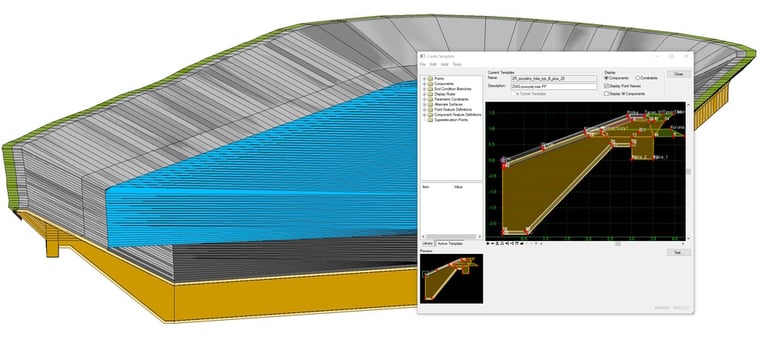
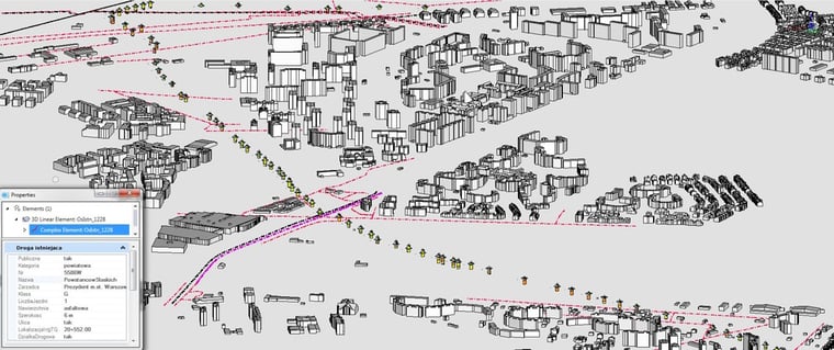
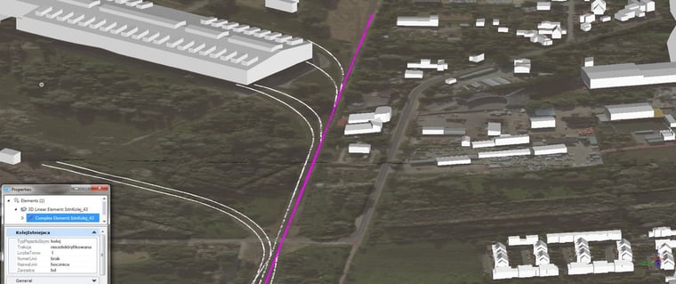
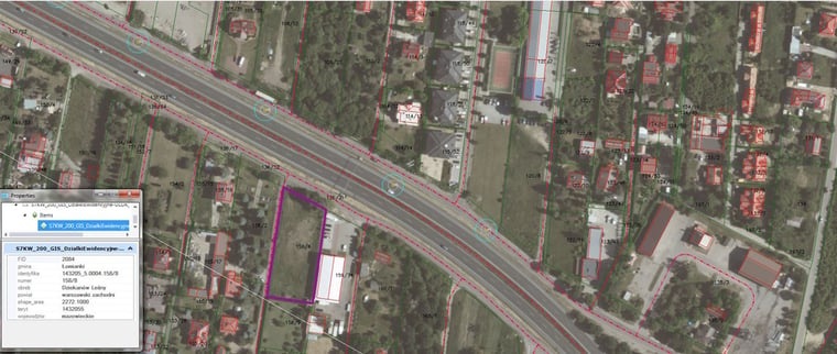
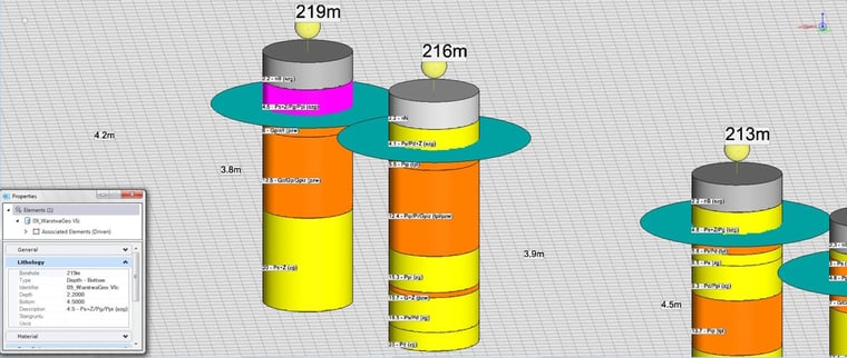
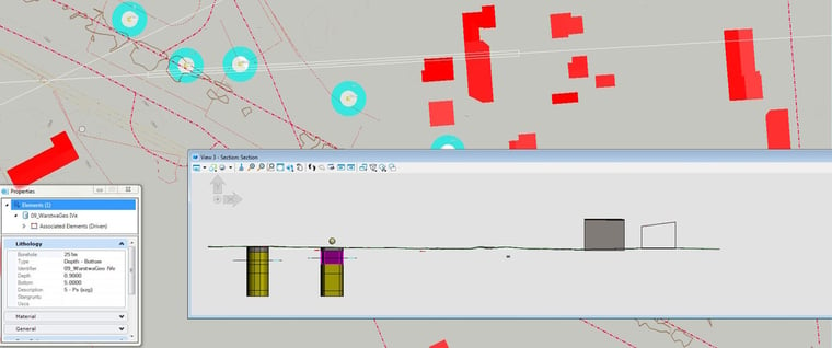
In accordance with the assumptions, the basic tool in the design work was OpenRoads Designer. Thanks to its functionality, it was possible to design 3D solutions for the road, land reclamation, sanitation, power, telecommunications, road safety, as well as to create a model of the existing state. The OpenRoads tools allowed for the aggregation and ordering of data on the existing land development in the scope of maps, digital terrain models, models of existing buildings, aerial photographs, point clouds, or GIS data. From scratch, 3D models of existing roads, railways, drainage channels and land development networks (underground and above-ground) were also created. The results of geological surveys were also presented in 3D.
MicroStation was the basic tool for interdisciplinary coordination and preparation of 2D documentation. Automated, drawing sheets, metric sheets with their content were developed with it, and the process of generating print files (PDF) was accelerated. MicroStation was also used as a tool for reviewing and presenting the project within the organization. Internal summary files (3D models, site plans, profiles, sections) were created with it, which made it possible to access project information quickly and easily for all interested parties.
Additionally, using MicroStation as the basic drawing tool, all elements of the 2D design documentation, not directly resulting from the interdisciplinary model, such as sketches, schematics, or construction details, were prepared. The Bentley View program was used as the basic tool for reviewing and presenting the project outside the organization, including for performing simple analyses such as measurement or reading parameters.
Q. How did using these digital solutions help you overcome the challenges you faced?
The use of MicroStation allowed for the creation of a multi-disciplinary 3D model that was used for coordination of solutions. Here the use of MicroStation as Data Integrator has been proven to be an efficient solution. Thanks to it, many collisions were detected much earlier, which due to the stage of the design work would not have been possible to detect on 2D documentation. The dynamic change functions of OpenRoads Designer allowed for the analysis of many road solutions in a brief time. The geometric elements of all disciplines were saturated with parametric data using the Item Types and Asset Manager functions. This allowed for quick access to information about existing and proposed elements and significantly facilitated the process of measuring and cost estimating.
Q. Did you achieve a return on your investment by using these Bentley solutions for this project?
The use of Bentley’s MicroStation allowed for an increase in the productivity of the design team by saving time in the analysis of design solutions, searching for project information and generating project documentation. Due to the high level of multi-disciplinary coordination, the Investor received a higher quality product that will reduce the number of changes at the next design stage. Here the use of MicroStation as data integrator has been proven to be an efficient solution.
Q. How did using Bentley's solutions and applications help your organization better serve its customers, community, and environment?
The use of Bentley's software tools allowed for the creation of a multidisciplinary 3D model, which was used for coordination purposes – MicroStation was their major Data Integrator for the whole project. This allowed for the early detection of many collisions that would not have been possible to detect on 2D documentation at the stage of design work. The dynamic change functions of OpenRoads Designer allowed for the analysis of multiple road solutions in a brief period of time. The geometric elements of all disciplines were saturated with parametric data using the Item Types and Asset Manager functions. This allowed for quick access to information on existing and proposed elements and facilitated the process of pre-measurement and cost estimate.
Q. This is such an interesting project and technology story. What would you consider the major advantage of the use of MicroStation?
The major advantage of MicroStation is its flexibility as a data integrator. In our case, all discipline models were collected in one coordination DGN file. MicroStation allows us to access (read, analyze, copy, import) any information included, both in complicated 3D road models from OpenRoads Designer with many item types and also in simple plan/sketches or GIS data.
There was no data loss reported during the design process. What is more, complicated discipline models from OpenRoads Designer are much more presentation friendly in MicroStation. It was crucial for us to use it in internal coordination meetings or to show the model externally. The MicroStation exporting tools allowed us to deliver design data very quickly to our subcontractors and third parties.
Furthermore, the coordination model was able to import files created in older versions of Bentley software or in different programs to DGN file types which you can’t avoid in large infrastructure design processes. Finally, MicroStation as a data collector allowed us to import data in the opposite direction. From comments or sketches prepared in coordination DGN files, discipline designers could derive geometrical elements or data (parameters, numbers) directly to OpenRoads Designer or any other design tool.