OpenFlows WaterGEMS Has Unique Platform Interoperability
Often, time is the largest constraint when designing water networks. Having the most efficient design solution in place can help save valuable hours in your project timeline. This helps reduce project costs, allows you to complete projects more quickly, and frees time that could be used for other projects. By allowing your team to work from within a familiar environment such as CAD or GIS, you save time switching between platforms and avoid the learning curve of a new interface. It is essential for your team to have the flexibility to choose where they want to design their water network models.
Integration with CAD and GIS platforms allows engineering teams to create, manage, publish, and share 2D and 3D drawings, geographic maps, BIM data, and models. This allows more comprehensive results since they can be visualized and displayed on multiple platforms in a more collaborative workflow.
With WaterGEMS, you can integrate with the leading engineering software to deliver accurate and optimal designs. With the option of working in different platforms, you can maximize the potential of your results while saving crucial design time by working where you are most familiar. You can design where you feel most comfortable and use the integration platform that best improves workflows and collaboration between teams.
GIS & CAD Workstations for Engineers
Efficiency and ease of use is paramount when selecting your software solution. WaterGEMS allows engineers to work in the environment that is most comfortable for them, whether that is GIS, CAD or the native WaterGEMS Standalone window. This enables them to more effectively complete modeling tasks in less time.
I want also to add that you can speed up the learning curve with the Keys that are included in every Virtuoso subscription. These Keys grant access to training sessions tailored to your challenges and needs so you can overcome difficulties in mastering your solutions. In that way you will be able to use Bentley’s software to its fullest potential, therefore making the most out of your investment and every working hour.
Facilitate Team Collaboration with WaterGEMS
WaterGEMS easily allows collaboration between teams. No matter where you want to design, whether in a GIS or CAD platform or even within MicroStation and in the Standalone version, you will be able to use the same file. This helps avoid multiple versions of the same model and communication errors. Your team can collaboratively share one file.
The ability to run WaterGEMS in different platforms increases the range and depth of the workflows and analyses your team can perform to design water supply networks. It does this by leveraging the built-in features from CAD and GIS applications.
Running WaterGEMS within CAD platforms (MicroStation and AutoCAD) improves design capabilities. This integration allows designers to create detailed drawings and 3D drawings for BIM (Building Information Modeling).
Using GIS (ArcGIS Pro and ArcMap) as the chosen platform for WaterGEMS allows designers to leverage using complex spatial data and managing/accessing large amounts of information about sites, spatial analysis, geography to assess potential impacts and emergency planning.
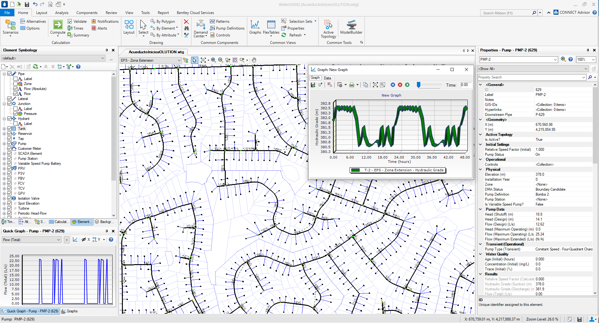
OpenFlows WaterGEMS is Standalone
Operating WaterGEMS as a standalone platform allows for optimal model performance and speed. This option increases the ease of use as all the tools are readily accessible, without additional subscriptions costs or third-party software for analysis or design. A sample screenshot from the standalone interface is below.
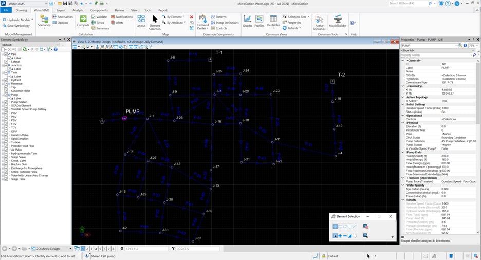
OpenFlows WaterGEMS Integrates with Bentley Solutions
OpenFlows WaterGEMS also integrates with MicroStation, allowing engineers to bridge the gap between geospatial planning and engineering design environments. This integration allows designers to work in a familiar environment and maximize their efficiency. MicroStation integration also allows designers to create 3D drawings for BIM (Building Information Modeling). A screenshot of OpenFlows WaterGEMS incorporated into MicroStation is shown below.
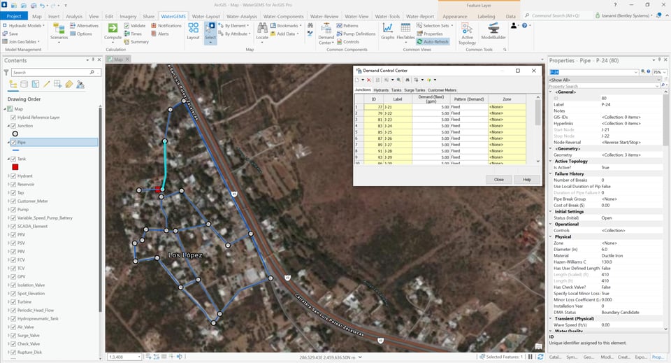
WaterGEMS Integration with ArcGIS Pro and ArcMap
WaterGEMS can integrate with both ArcGIS Pro and ArcMap – for no additional cost! This integration allows engineers to design and analyze water networks seamlessly while leveraging GIS capabilities, such as the advanced geographic maps in the native ArcGIS Pro functionality. This interoperability can be used for thematic mapping and publishing. The integration of WaterGEMS with GIS is shown below.
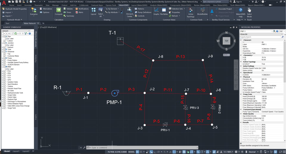
OpenFlows WaterGEMS Integration with AutoCAD
Integrating WaterGEMS with AutoCAD allows for convenient CAD layout and drafting of your model. Designers can continue working in their typical CAD environment, lessening the learning curve and enhancing the modeling process. See the integration of WaterGEMS in CAD below.
WaterGEMS Integration Compatibility
Understanding your platform capability potential is important to maximize the value of WaterGEMS. Upon installation, integration will be automatically setup with any existing platforms you have. A full list of platform version compatibility can be seen here.
Learn More
Interested in learning more about WaterGEMS? Contact one of our experts.
- North America Contact – Linsey Henderson, Product Sales Engineer, Linsey.Bowersox@Bentley.com, 610-458-2705
- Latin America and Caribbean Contact – Julio Issao Kuwajima, Product Sales Engineer, julio.issao@bentley.com, +55 11 2823 2656
- Europe, the Middle East, and Africa – Rua Suleiman, Product Sales Engineer, suleiman@bentley.com, +971565113354