Construction has always been classified as a core industry that directly affects an economy’s growth, because of the sheer number of jobs it creates, and the vast amount of services involved throughout the entire lifecycle of a project. As a direct response to tackling the negative economic effects of COVID-19, local governments are emphasizing construction as part of their recovery plans.
In turn, these recovery measures can support this sector transformation towards sustainability and digitalization. Drones and photogrammetry can form a massive part of this modernization.
Construction can involve a lot of processes and this is where the versatility of drone-based imagery can shine, below are just a few examples of modern-day trends that have become more prevalent in a post-Covid world. In essence, they all follow the same simple workflow:
- Use a drone to capture images of a site.
- Load this data into ContextCapture.
- Produce a 3D model.
Building surveys, site inspection, and progress reports
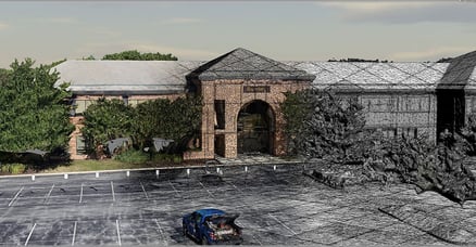
Gone are the monthly progress reports with a switch to this weekly style of reporting is now far more common. Budgets and timelines are tight and the need for up-to-date to respond to design changes, progress reporting, and logistics has become vital as companies push to fewer employees to be on site. Having a 3D model eliminates the need to gain roof access or tricky areas. The 3D model can be georeferenced and scaled, meaning you can easily virtually walk through a site and understand its surroundings, measure distances, volumes without interrupting on-site work. Due to the efficiency of drone capture, a site can be easily captured at frequent intervals, meaning you will always have an up-to-date digital representation. A prime example of this is the work by Eye-bot. They used ContextCapture to survey a 450-acre site every week all within a 72-hour window, this acts as a single source of truth which helps to optimize collaboration and decision-making.
Training and simulations
Public engagement
A real modern trend for the traditional paper-based industry, effectively communicating conceptual designs to the public/stakeholders has become an integral part of the tendering process. Traditional 2D platforms are being replaced by interactive 3D environments that lean towards the easy consumption and sharing of data. What is the average person more likely to understand a 2D plan, or a 3D scene more akin to a video game or Google Maps?
The construction industry has always thrived for a more digital approach as it offers increased availability, reduced risks, improved production. But COVID-19 has shown a dramatic adoption rate like never before. Above I have mentioned some dramatic changes to workflow, that stem from a simple drone or photo survey. If you would like to provide the very best service for your clients and stay ahead of the competition, please visit us at www.virtuosity.com. Each one of Reality Modeling bundles comes with tailored one-to-one training and support, to ensure you are confident in tackling these modern-day trends. 